


Boxing Day 26th Dec 2019
- Karen Partridge
- Dec 27, 2019
- 5 min read

Up early and off to the Fairy (Faery) Glen, the boys choose to take their own car today rather than squeeze into the back of ours. We had a refreshing stroll through the rolling hills of the iconic Fairy (Faery) Glen. Unfortunately, I was unable to make it all the way due to the steep incline and angle of the approach, causing my leg to become extremely painful. So I sat on the hillside for a while as the others went onward.

Morag kept me company resplendent in her Christmas present of a Harris Tweed Coat but she was a trifle naughty on the way back as she leapt out of my pocket and started playing with the Faeries - luckily I realised she was missing as I made my way down the other side of the glen, and returned to find her happily waiting for me - cheeky thing!


The boys return heralded and easier and less demanding route around to the left hand side instead of up and over, so next time I come that’s where I will go!
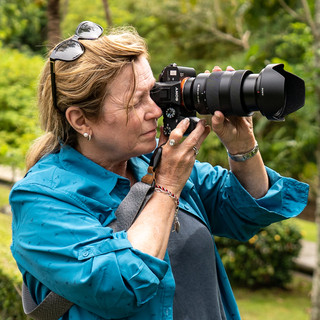
Vince recorded another YaYa Vlog at the Fairy (Faery) Glen. This is one of many locations we are checking out as possible wedding photo shoots. It certainly seems promising, provided I can get to the other side with the alternative route the found.

Next it was off to Portree Co-op to get some supplies - including kindling - warm tootsies tonight! We grabbed some ready made sandwiches and a couple of sausage rolls for lunch on the go. We got a few extra supplies, and I was able to source a replacement side-plate!
We headed down to Sleat, where we dropped off the balance of the money to Penny (Photographer) that had been inaccessible at our meeting on the 23rd. To our surprise she and Clive (partner) were outside with their three gorgeous dog, looking skywards. There was a Golden Eagle soaring on the wind above. I got out my binoculars for a closer look and confirmed it certainly was an Eagle. Within minutes it was joined by a second Eagle. We have been so lucky since arriving in spotting them. Penny invited us in for a cuppa but we had to get along to catch up with our friends.

Driving on we saw a third Eagle soaring - how exciting! We took the road to the Ord Loop and that turned into quite the experience, including getting COW BLOCKED. We counted to try get to the 14th cattle grid as advised by Penny, but alas there weren’t that many and we got to the end of the loop without seeing Dunscraith Castle, which we were considering as a wedding photo location. We double backed and eventually found it. Dunscaith Castle also known as Dun Scaich, Dun Sgathaich Castle and Tokavaig, is a ruined castle on the coast of the Isle of Skye, in the north-west of Scotland. It’s also know as the Fortress of Shadows, and is named after the Scottish warrior maiden Scathach, who legend says conducted martial art training there and trained the hero Cu Chulainn in the art of combat.

After the long drive I desperately needed to go to the toilet but nothing was close. So I just sat in the car, trying not to move, whilst the boys went for the walk out to the Castle ruins to check it out. Verdict- probably not suitable for our wedding photos!

Exiting the Ord Loop we were back on the main road headed for Broadford, where we stopped for fuel at the Co Op and I was finally able to use the loo!!!!

We headed back towards Portree and stopped near Sligachan Bridge to get some shots of the spectacular sunset over the Cuillins, and a very photogenic Highland Cow who was happy to pose for me.


We took the East Coast road home to North Duntulum, passing by the Old Man of Storr and the Quiraing, but as it was already dark we didn’t stop.
The Old Man of Storr is an iconic Skye landmark not to be confused with the Old Man of Stoer which is a 60m Seastack in Sutherland, Scotland. The Storr (An Stòr) is a rocky hill on the Trotternish Peninsula, created by an ancient massive landslide on the Isle of Sky. The hill presents a steep rocky eastern face overlooking the Sound of Raasay which contrasts against gentler grassy slopes to the west.
It is probably the most famous walk on Skye and often very busy but not one we would have time for today. The Old Man is a large pinnacle of rock that stands high and can be seen for miles - we saw it in the distance as we approached Portree on our first day on the Island.
The walk uses the same path up and down (like the Fairy Pools) returning to the same point in the carpark. It covers almost 4 km so it not for the faint hearted being considered medium length and difficulty by hikers and the top section is reportedly muddy and slippery, it’s been described as rougher and in poor condition. It takes around 45 min to reach the foot of the Old Man of Storr, longer if you take rest stops. There are gates along the way designed to keep deer out, so you need to close them behind you. At places the path splits, the best routes are to go right at the first break and left at the second break as you face uphill (the Old Man of Storr with be on your far right as you go up) the path will eventually turn to face the foot of the Old Man of Storr.
From the foot it becomes very steep and is a bit of a scramble - so not suitable for all but the views from the top are fantastic and look out to sea over the Islands of Raasay and Rona, then beyond to the mainland. Looking South you can see Storr Lochs, Portree and the Cuillin Hills. For the brave there are other neighbouring rock structures to explore.
The route back is just in reverse, but easier as it is going down hill, it’s estimated to take round 30-40 min back.
Another iconic site on Skye is The Quiraing (A' Chuith-Raing) a landslide on the eastern face of Meall na Suiramach, the northernmost summit of the Trotternish Peninsula on the Isle of Skye. It’s name comes form the Old Norse Kví Rand', which means "Round Fold". Within the fold is The Table, an elevated plateau hidden amongst the pillars. It is said that the fold was used to conceal cattle from Viking raiders.
The whole of the Trotternish Ridge escarpment was actually formed by a great series of landslides; the Quiraing is the only part of the slide still moving—the road at its base, near Flodigarry has to be repaired every year.
Parts of the landscape are very distinctive and descriptive- the Needle is a jagged 120-foot (37 m) high landmark pinnacle, a remnant of the land slide. Northwest of it is The Table, a flat grassy area slipped down from the summit plateau, with vistas of the Torridon Hills and the mountains of Wester Ross. Southwest is the Prison, a pyramidal rocky peak which when viewed at the right angle resembles a medieval keep.
We also saw the road to Flodigarry (the hotel where we were originally going to have our reception but they decided not to open at that time of year after all).
The silhouette of the Trotternish Ridge against the blue hour sky was just spectacular. We are not religious, but if there is a God then this is God’s own country. Just MAGNIFICIENT!
Dinner was quick and simple (butter chicken and rice) and I made some damper for afters - Yum! Another casualty in the kitchen though as I put the corning wear pan into the sink to soak, the cold water hitting one side cause a clean split of a corner off on the other side. So I will look in a charity shop tomorrow to find a replacement.


Should have taken your She Pee with you. Food and toilets????? Cheers Jacks.